Are you looking for a hike in Tenerife with some impressive views? The moderate and relatively short hike from Taganana to El Bailadero will reward you with some pretty cool views of the lovely village, the ocean, and the lush greenery of northern Tenerife.
This page contains affiliate links. If you buy through these links, I may receive a small commission, at no additional cost to you. I only recommend products or services I have tried and/or find useful and reliable.
The beautiful village of Taganana is a place you shouldn’t miss in Tenerife. But if you want to add a bit of a workout to your visit, I recommend doing the Taganana to El Bailadero hike. This trail offers incredible views of Taganana from above and a little cardio exercise.
Mirador El Bailadero also has some great views, but they are not as impressive as the ones you’ll get to see throughout the hike. So, if you’re thinking about skipping the hike and driving to the viewpoint, I would recommend reconsidering. That is, of course, if you can do the hike.

Taganana to El Bailadero Hike: How to prepare
While the hike is not very difficult, it is quite steep, so be prepared. The elevation is roughly 700m above sea level, which you reach over more or less 3 kilometers. I am a big fan of hikes, but I’m not exactly an expert hiker, so I did break a sweat and had to stop quite a few times to catch my breath. That may also be due to my habit of going full speed until failure and then stopping for a minute to recover and admire the view.
Overall, the hike took me around 2.5 hours. However, I did stop quite a few times to take pictures or just enjoy the view. If you walk without stopping, the hike should take roughly 1.5 hours. Anyway, I would recommend setting aside three hours just to be on the safe side and have enough time to take a break if you want to.

You can do this hike in both directions, and depending on your means of transportation, you may start at different points. I’ll tell you about my experience and try to include a few alternatives.
If you’re short on time and enjoy guided group tours, you can join one to save time and learn more about Taganana and its surroundings. Here are a couple of options:
The weather in Taganana
I did this hike at the beginning of February, and the weather was great, sunny but not too hot, like any other “winter” day in Tenerife. I would assume it would be much hotter during the summer months and maybe not ideal, but I wouldn’t be sure. Just a quick tip: don’t rely on the weather forecast, as it rarely reflects reality in the Canary Islands. The weather can change quite a lot during the day, so pack accordingly.

I recommend dressing in layers and bringing something to protect you from the rain, just in case. And don’t forget to wear proper shoes. The dirt trail is quite narrow, with some rocks and some parts covered in dry leaves, depending on the time of year. This means some parts could be slippery, so don’t overestimate the importance of a good pair of shoes. I wore running shoes, and it was okay, but hiking shoes would probably be better.
How to get to Taganana
I explored Tenerife just by bus and on foot, and I found it fairly easy to reach most places. Having a car has its advantages, especially if you’re short on time. But if you don’t want to rent a car, worry not. Tenerife has a great public transportation system (remember, buses are called guaguas in the Canaries). You can find all the details on titsa.com. Plus, when traveling by guagua, you’ll be more eco-friendly, which is always a bonus.

You can reach Taganana from Santa Cruz de Tenerife by guagua line 946 in about one hour. Alternatively, lines 077 from San Cristóbal de La Laguna and 947 from Santa Cruz stop at El Bailadero. These are good options if you want to do the hike in the other direction. This may be a bonus since it’s going to be downhill. Although personally, I sometimes find walking downhill even harder, especially if the trail is very steep. And let’s face it, climbing to a peak is more rewarding than descending.
One thing to keep in mind is that there are fewer buses during the weekend, so make sure to check the schedules in advance. In particular, lines 077 and 947 only have a few rides, even on weekdays. So, your best option is going to be line 946, which also stops at El Bailadero if you want to catch it on the way back (what I did).
Before your hike: About Taganana
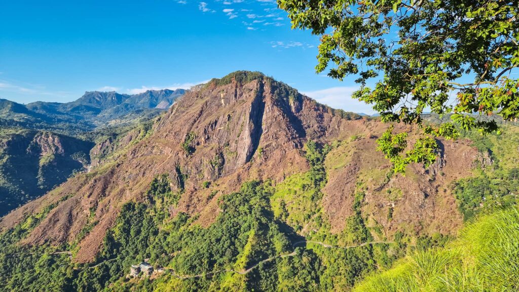
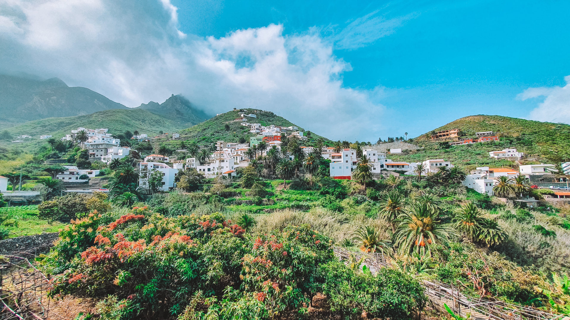
Taganana is a small village and the main settlement in the Anaga Rural Park, in the northeast of Tenerife. Small white houses are scattered among the palm trees and the rich vegetation that covers the surrounding mountains, creating one of the most beautiful landscapes in Tenerife. The small valley expands from the feet of the Anaga mountains to the ocean. The impressive cliff Roque de las Animas towers over the village and can be seen from any spot in the valley.

Before starting your hike towards El Bailadero, I recommend walking around and discovering the narrow alleys of this little village. I feel like every few steps, you’ll find a new angle offering amazing views of the surrounding valley. Palm trees, colorful flowers, and the occasional dragon tree seem to blend with the small white houses, creating a perfect balance between nature and man-made.

And don’t forget to check out Iglesia de Nuestra Señora de las Nieves, one of the oldest churches in Tenerife, dating back to the 16th century. Around the church, you’ll also find a few restaurants if you want to stop for lunch or just for a coffee or cold drink. Once you’re done exploring Taganana, walk up Camino Lomo los Lirios to reach the starting point of the hike. You’ll also find a few plaques indicating the way to El Bailadero around the village.
Short stop in Almáciga
First of all, let me say that I enjoy walking and, whenever I can, I get off the bus and walk to enjoy the views. So, for this hike, I actually went by guagua (line 946) all the way to Almáciga, and I walked back to Taganana. I wouldn’t necessarily recommend doing this since the walk from Almáciga to Taganana is mainly on the side of the road, with no sidewalk or walking trail. However, it is quite short, so it’s doable if you want to.

Almáciga itself is a lovely village, very small, right on the coast. Its beaches, Playa de Almáciga and Playa del Roque de las Bodegas, are popular for surfers. If you’re planning on doing some surfing, you should check them out. The bus stops in the upper part of the village, offering some pretty amazing views of the coast. From there, you can descend along a small trail down to the coastal part and walk along the beach towards Roque de las Animas. It’s the big cliff, you can’t miss it.

Along the way, you can stop at Roque de las Bodegas. The name of this rock, which translates to Wineries Rock, is due to the stone houses that used to be here, where the wine from Taganana would be macerated. The area used to be very important for the local economy, and many merchants who came from Northern Europe would stop by to buy wine barrels. Anyway, after you check out the rock and the tiny village of Almáciga, you can make your way to Taganana to begin your hike.

Camino Abicore
The Taganana to El Bailadero hike is part of the Camino Abicore, a trail that connects Taganana to San Andres on the opposite coast of Tenerife. If you have enough time and you enjoy long hikes, you could walk the entire 8.5-kilometer trail, which takes around five hours of steady walking. Camino Abicore is unique since it’s a historical trail that has been kept intact since pre-Hispanic times.

Obviously, you can do this in both directions. The trail is very easy to follow from Taganana to El Bailadero, but I read it is not well signposted in general, so it may be trickier for the remaining part. For all my hikes, I use Maps.me, a navigation app that works great even offline. Maps.me shows even the narrowest trails that you won’t find on Google Maps. Once you download the map of Tenerife, it’s easy to navigate offline.
Taganana to El Bailadero hike
If you’re doing the hike from Taganana, as I did, it begins at the end of Camino Lomo los Lirios. For a minute there, it may seem like you’re entering private property, but don’t worry, you’re on the right track. You’ll soon be able to see the narrow dirt trail making its way through the lush greenery (at least if you’re walking the trail in late winter). As you climb further up, you’ll be able to have a better view of the ocean, as well as the valley, dominated by Roque de las Animas and Roque del Medio, right next to it.

On your way up, you’ll come across a peak with some rocks where you can rest and just enjoy the view. From there, keep climbing up, and soon you’ll reach the forest. During the last part of the hike, you’ll no longer be able to see the valley. Nevertheless, the vegetation is still pretty impressive. The very last part of the hike, before you reach the main road, has some wooden steps that make the climb easier. A small wooden sign signaling the Camino Abicore will let you know you’ve made it to the top.
From there, you can either proceed along the main road to El Bailadero or take the trail on the other side of the road. I chose to walk on the main road because it looked shorter. In less than 10 minutes, you’ll reach El Bailadero, and on the way, you can admire the view of the valley on the opposite coast.

Mirador El Bailadero
Mirador El Baliadero will reward you for your effort with some impressive views of the valley of Taganana. From here, you can see everything, from the rugged mountains surrounding the valley to the unusual shape of the Taganana village, with lines of small white houses spreading like arteries from Iglesia de Nuestra Señora de las Nieves, in the heart of the village, towards the foot of the mountains.
El Bailadero is a mysterious place tied to old legends. According to one of them, the name of the place comes from a propitiatory rain ritual called “Baladero” that locals would perform by blowing the cattle to attract the attention of divinities.
Another legend is tied to the Witches of Anaga, who lived in covens in the area and performed rituals like dancing around the fire, hence the name “El Bailadero”. After these rituals, the witches would go down to the coast to swim naked.

Enjoy the views from El Bailadero and read more about the place on the plaques that you can find along the way. From here, you can walk for around 10 minutes to the bus stop El Tunel to catch bus number 946 back to Santa Cruz, or you can continue walking along Camino Abicore to San Andres. Alternatively, you may follow the same road back to Taganana.
El Bailadero to Taganana hike
If you plan on doing the hike in the opposite direction, starting from El Bailadero, you can park your car near the viewpoint or go there by bus. The bus stop for lines 077 and 947 is right next to the viewpoint. If you take line 946, you’ll need to get off at the stop El Tunel and walk for around 10 minutes to Mirador El Bailadero. From there, you have two options. You can either walk along the main road to the beginning of the trail or take a longer route along the hiking path.
As usual, make sure to use Maps.me to find the best trail here. Since I did this part on my final stretch and I wanted to catch the earlier bus, I walked along the road, which was faster. There is no sidewalk, but with a bit of caution, it’s doable. When I did the hike, there weren’t many cars driving by.

Just off the road, look for the sign that says Camino Abicore. From there on, it’s all downhill to Taganana. At first, you’ll walk through the forest, and after a while, you’ll be able to see the beautiful valley, the village, and the ocean in the background.
Useful information about Tenerife
I spent a full month in Tenerife between January and February, and I would say it’s a great place to escape the European winter. Although this may technically be low season, it does not mean you won’t come across other travelers. The Canary Islands are especially popular among Northern Europeans who escape their cold countries to spend the winter at the beach.

To find accommodation in Tenerife, I always recommend Booking.com, where you can find lots of options for every budget and type of accommodation, from hostels to apartments. I stayed close to Puerto de la Cruz, on the northern coast of Tenerife. I would recommend this area as a base more than the south of the island, which tends to be more crowded and touristy.
One thing I always recommend, especially when you’re going to embark on adventures like hiking or any sports, is to have health and travel insurance. My favorite is SafetyWing, the perfect choice for nomads or for traveling to multiple destinations. It provides coverage nearly worldwide, and you can even sign up while you’re already traveling. Sign up here or read my detailed article about SafetyWing for more info.
Tenerife is full of amazing places and beautiful hikes. I’ve traveled to the island three times and spent roughly two months there overall. More articles will be coming soon. In the meantime, you might enjoy checking out my other Tenerife articles:
- 10 Must-see Places in Tenerife on Your First Trip
- Short Trip to the Quaint Town of Garachico
- Nine Awesome Tenerife South Activities
- The Charming Village of Boca Cangrejo
- Off the Beaten Path on Sendero El Jagre
Enjoy your trip around this amazing island!

Travel Resources
Here are my go-to travel resources. Time to start planning your Tenerife trip!
| Website/App | Category | Description | Book Here |
|---|---|---|---|
| Booking.com | Accommodation | My favorite website for great accommodations for different budgets. | Find a Place |
| Kiwi.com | Flights | My new favorite platform for finding affordable flights. | Find Flights |
| Omio | Transportation | You can book everything from buses and trains to ferry rides. | Transportation |
| SafetyWing | Insurance | One of the best travel medical insurances for frequent travelers. | Get Insured |
| Manawa | Activities | A great platform to book activities and adventures with local hosts. | Find Activities |
| GetYourGuide | Activities | My go-to platform for tours and experiences with lots of options. | Experiences |
| Viator | Activities | A great alternative for activities all over the world. | Experiences |
| GuruWalk | Free tours | A great platform for free walking tours (tipping is recommended). | Book a tour |
| DiscoverCars | Car rental | My go-to platform for car rental anywhere in the world. | Rent a Car |
| Airalo | eSIM | My favorite app for buying digital SIM cards when traveling abroad. | Get an eSIM |
| Saily | eSIM | A great alternative to Airalo, with cheaper plans in some destinations. | Get an eSIM |
| Xe | Currency | A currency converter showing real-time rates. Website or app. | Get Xe App |
| Maps.me | Navigation | My favorite navigation app for hiking trails and remote areas. | Get Maps |
Pin this for later!